Mumbwa Project
Project Location:
The concession lies in the Central Province in Mumbwa 160km Northwest of Lusaka.
Figure 1 below shows Geographic location of the License area:
At the epicenter of the license area lies town Mumbwa. The license area is easily accessible by a tarred road covering the Mumbwa town.
Legal Aspects and permitting:
Magna mining wholly owns and holds an exploration license covering an area of 31 946 Ha.
Figure 2 below shows Mumbwa Licence 21700-HQ-LEL Concession Boundaries (red square below):

Project Overview:
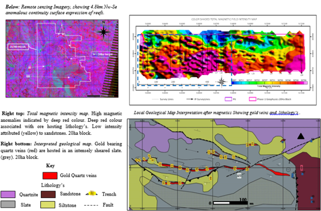
Magna holds a large exploration license held in Zambia covering 32946ha. To date only 6.5% of the area has undergone basic Geologic exploration. With a 20ha block having undergone detailed evaluation. The project is still open ended with mineralization expected to extend along an additional anomalous strike length of 4.8km.
Exploration to increase resource inentory has been planned for in two stages Phase one to increase resource inventory to 256 000ounces (estimated $ 442 000 000usd) and phase two to increase inventory to 620 000ounces (estimated $1 000 000 000Usd).
Regional and Local Geology Summary:
The license areas lie within the extreme southern portion of the Neo-Proterozoic Lufilian arc. The lufilian arc s a large fold and thrust belt covering the northwestern part of Zambia into DRC. The prospect lies within the Mumbwa formation mainly hosting carboniferous calcerous rocks, ironstones, arenites, sandstones and quartzite’s.
Shear-zone extent:
Target ore hosting lithology’s are characterized by sheared folded shale/slate formations invaded by pervasive milky and ferruginous quartz. The shales forma an extensive shear zone covering 4.80km on surface. The mineralization corridor (quartz breccia) is bound between the shalitic beds forming sharp contacts. The auriferous quartz breccia measured from trenches ranges 3-4m in thickness with an adulatory dip of 65°to 50°.
Exploratory work included:
- Geophysics work (Magnetics, Induced polarisation)
- Trenching and sampling 42 trenches and 6 pits
- Metallurgical test works preliminary
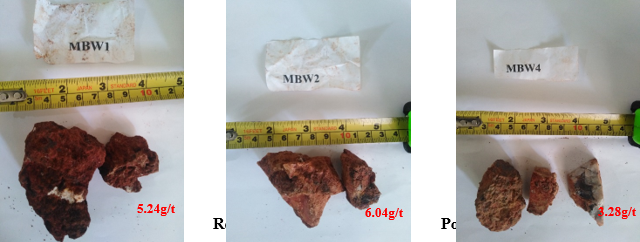
Phase one exploration defined isolated gold ore occurrences averaging 4.33g/t hosted in oxidized quartz veins. Closed spaced trenching from a total of 42 surface trenches defined a gold reef averaging 2.58g/t over 3m. Preliminary metallurgical test works on the auriferous quartz reef yielded recoveries above 85%.
Exploration geophysics (magnetics and I.P) was gave positive anomalies on prove down dip continuity of the gold reefs down to 100m.
Style of mineralization:
The gold is structurally controlled, hosted in deformation zones within ferruginous quartz veins. The veins average 3m in thickness dipping at 70degrees. Mineralization has been mapped on hinges and tail ends of a slate fold structure.
Resource Opportunities:
The Exploration license area is large in excess of 31 946ha. At present only 6.5% of the area has been explored and multiple gold occurrences and gold bearing formations A 20ha Block from an anomalous 4.8km northwest-southeast striking shear zone target was selected and evaluated.
Spectral features of ferric and hydroxyl – bearing minerals in which hydrothermally altered rocks are often rich was used to create a false colour composite using band combinations (7/4; 5/7;4/3)
Band ratio compiled from 7/4, 4/3 and 5/7 RGB. After Qgis.
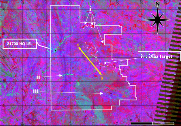
Above: Red components indicate hydrothermally altered zones with minerals containing iron oxide (ii) The cyan color component (off) the river drainages is indicative of vegetated zones. (iii)Carbonate bearing minerals are pre-dominantly shown as blue correspondent. iv) 20ha with proven gold mineralisation
The line A-B defines a regional a shear zone trending Northwest South east hosting the auriferous gold bearing quartz veins striking for an estimated 4.8km.
Remote sensing, Geophysics, Geo-map